Most of these trees are invisible to most satellites but have finally been counted
The Sahara, one of the driest places in the world, is not just an expanse of sand but hides numerous trees. At first glance, the seemingly arid expanses of the Sahel and Sahara deserts show little vegetation, but detailed satellite images combined with computer models revealed a different picture.
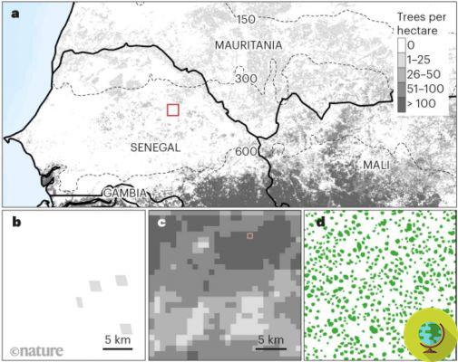
Even in the driest deserts on Earth, there are billions of trees. According to the new study by Martin Brandt, a professor of geography at the University of Copenhagen, some 1,8 billion trees dot parts of the Sahara, particularly in West Africa, the Sahel deserts and the so-called sub-humid zone. This luxuriant vegetation, hitherto unknown, overturns previous hypotheses about such habitats.
“We were very surprised that there are (so) many trees growing in the Sahara Desert,” lead author Brandt told AFP. "Of course there are large areas without trees, but there are still others with a high density of trees, and even among the sand dunes there are trees growing here and there."
The survey provides researchers with data that could help guide efforts to combat deforestation and more accurately measure earth's carbon storage.
"For conservation, restoration, climate change and so on, data like this is very important in establishing a baseline," said Jesse Meyer, a programmer at NASA's Goddard Space Flight Center who worked on the research. "In a year or two or ten, the study could be repeated to see if efforts to revitalize and reduce deforestation are effective or not."
Finding and counting trees is no easy task. In areas with many trees, they are clearly detectable in satellite images, even at low resolution, and are easily distinguishable in contrast to the bare earth.
But where they are most common, the images may be too low resolution to detect single trees or even small clusters. Even with high resolution ones, it is almost impossible to count trees, especially over large areas of land.
©Nature
A systematic review
Brandt and his team found a solution by pairing ultra-high-resolution satellite imagery with a specially trained computer program. A challenging process that saw Brandt individually count and label nearly 90.000 trees. It took a year to do.
“The level of detail is very high and the model needs to know what all kinds of trees look like in different landscapes,” he said.
The efforts paid off as once the program was trained, the results of work that otherwise would have taken years and personnel arrived within hours.
The study, just published in the journal Nature, covered an area of 1,3 million square kilometers and was based on over 11.000 images, revealing that the Sahara and Sahel are home to 1,8 billion trees.
The Sahara hides millions of lonely trees.
The use of very high resolution satellite images, combined with an artificial intelligence system, have revealed that there is much more green than previously believed in this portion of Africahttps://t.co/jdVeGDHv1o pic.twitter.com/ 5rpCtnBE5j
– Live Architecture (@arquitect_viva) October 15, 2020
The number of these solitary trees depends on the rains. In the hyper-arid areas of the sandy desert, the density of trees is less than 1% (0,7 trees per hectare) and increases with increasing rainfall, moving south. The figure rises to 9,9 trees per hectare in arid areas (annual rainfall between 150 and 300 mm) or 30,1 trees in semi-arid areas (between 300 and 600 mm per year).
“We detected over 1,8 billion individual trees (13,4 trees per hectare), with a median crown size of 12sqm, along a rainfall gradient of 0 to 1.000mm per year. Canopy coverage increases from 0,1% (0,7 trees per hectare) in hyper-arid areas, to 1,6% (9,9 trees per hectare) in arid areas and 5,6% (30,1, 13,3 trees per hectare) in semi-arid areas, 47% (XNUMX trees per hectare) in sub-humid areas. Although the overall vegetation cover is low, the relatively high density of isolated trees challenges prevailing research on dryland desertification and the desert also exhibits a surprisingly high tree density, ”the authors explain.
Thanks to this technique it will be possible map the location and size of each tree around the world. This will improve our understanding of ecology on a global scale and help determine the amount of carbon stored at these sites, which are not usually included in climate models.
But it is too early to say whether having an accurate life count of these trees will affect how we understand climate change and its acceleration. Scientists hope to use the technique elsewhere to map more trees previously hidden in the 65 million square kilometers of arid regions of the world.
"Our assessment suggests a way to monitor trees outside forests globally and to explore their role in mitigating degradation, climate change and poverty."
Each of these trees is a biodiversity hotspot, a real miracle in an area where life shouldn't even exist.
Sources of reference: Nature, ScienceAlert
READ also:
- The Sahara desert turns into a green expanse every 20 years. The discovery of MIT
- It rains more and more often in the Sahara: solar and wind farms are changing the climate